Chapter 7: Our Country India
NCERT Solutions for Class 6th Social Science GEOGRAPHY–
Chapter 7: Our Country India
Our Country – India
India is a country of vast geographical expanse. In the north, it is bound by the lofty Himalayas. The Arabian Sea in the west, the Bay of Bengal in the east and the Indian Ocean in the south, wash the shores of the Indian peninsula.
India has an area of about 3.28 million sq. km. The north-south extent from Kashmir to Kanyakumari is about 3,200 km. And the east-west extent from Arunachal Pradesh to Kuchchh is about 2,900 km. The lofty mountains, the Great Indian Desert, the Northern Plains, the uneven plateau surface and the coasts and islands present a diversity of landforms. There is a great variety in the climate, vegetation, wildlife as well as in the language and culture. In this diversity, we find unity that is reflected in traditions that bind us as one nation. India has a population of more than one hundred twenty crores since the year 2011. It is the second most populous country of the world after China.
India – Area and Location
Following are some facts about India’s size, area and location:
- The total area of India is 3.28 million sq. km. The total stretch of the country from north to south (Kashmir to Kanyakumari) is about 3,200 km. The east-west stretch (Arunanchal Pradesh to Kutch) of the country is about 2,900 km.
- India is located in the Northern Hemisphere. The Tropic of Cancer passes through the centre of the country at 23°30’ N.
- From south to north, the main land of India extends between the 8°4′ N and 37°6′ N latitudes. From west to east, India extends between the 68°7′ E and 97°25′ E longitudes.
- Due to its large longitudinal extent of about 29°, there are wide differences between the local time of two places, located far from each other, within India.
- In India, the longitude of 82030’ E is taken as the standard meridian for the entire country. The local time at this meridian is considered as the Indian Standard Time.
- The Himalayas and the fertile plains in the north, the Thar Desert in the west, and the plateaus, coasts and islands present the diverse landforms in the country.
- All across the country, there is a great variety in the climate, vegetation, languages, customs, and culture.
- After China, India is the second most populous country in the world.
India – Political Division
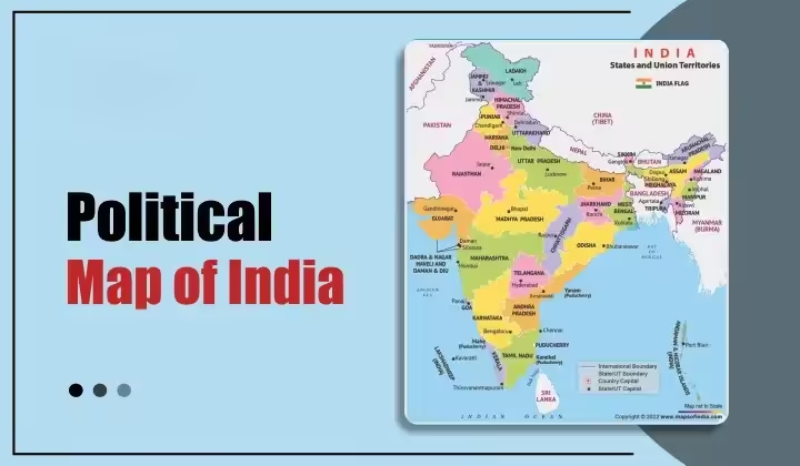
As the total stretch of India is large, our country is divided into 29 states and seven union territories. The states have been formed mainly on the basis of the languages spoken by the people. New Delhi is the capital of India. Rajasthan is the largest state while Goa is the smallest state. The states are further divided into districts and districts into towns and villages.
India’s Neighbours
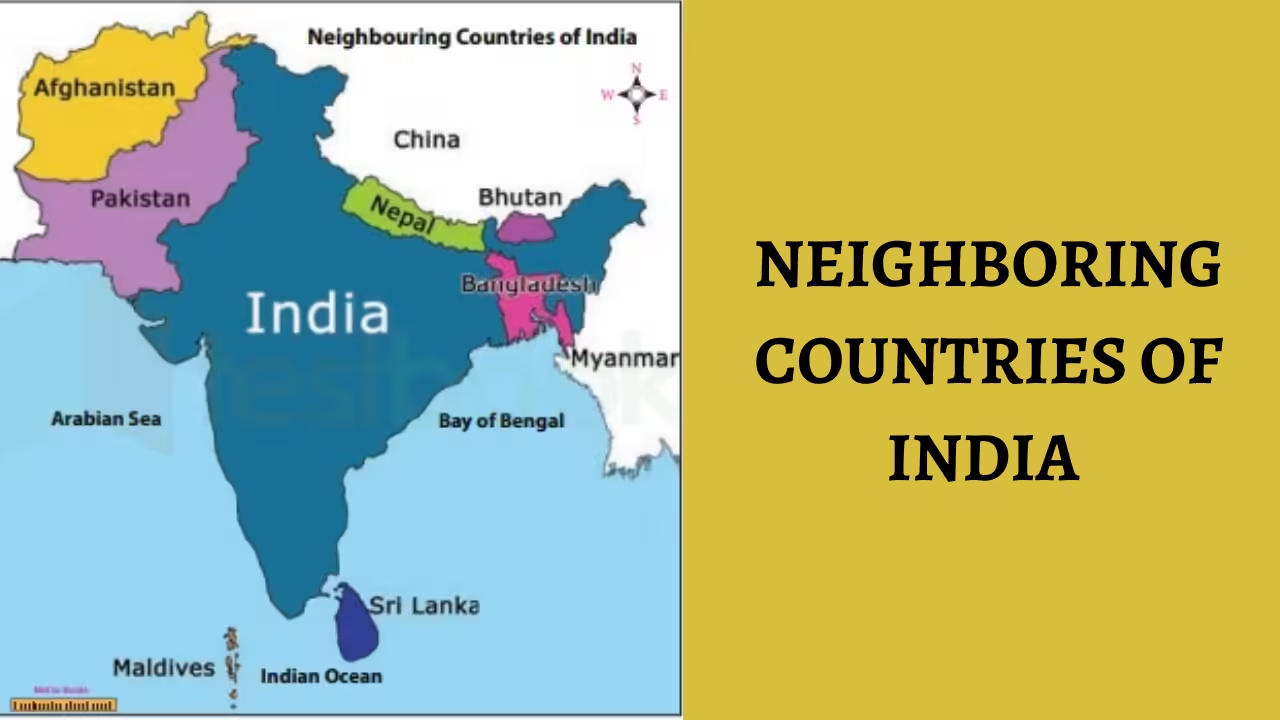
Since India has a long boundary line, it shares its geographical boundaries with seven countries, China, Pakistan, Bangladesh, Bhutan, Myanmar, Nepal and Sri Lanka. Sri Lanka is separated from India by the Palk Strait.
India – Physical Divisions
India has diverse physical features which can be broadly categorised as follows:
- The Himalayas: They form the northern boundary of the country. The Himalayas are divided into three parallel ranges. They are:
- The Great Himalaya or Himadri: This is the northernmost range of the Himalayas and some of the highest peaks are located here.
- Middle Himalayas or Himachal: This range lies to the south of the Himadri and is a home to many popular hill stations.
- The Shiwaliks: This is the southernmost range of the Himalayas.
- The Northern Indian Plains: They lie to the south of the Himalayas. These plains have been formed by the alluvial deposits brought down by the rivers Indus, Ganga and Brahmaputra and their tributaries. Due to the alluvial deposits, the northern plains are fertile. Therefore, this region is densely populated.
- The Great Indian Desert: It lies in the western part of India and hardly receives any rainfall. Hence it is devoid of any vegetation and is a hot, sandy and dry stretch of land.
- The Peninsular Plateau: This region has many hill ranges and valleys. The peninsular plateau is triangular in shape. The Aravalli ranges, one of the oldest ranges in the world, surround it on the north-west. The other important ranges are the Vindhyas and the Satpuras. The rivers Narmada and Tapi are important rivers in this region. The Western Ghats, also known as the Sahayadris, form its boundaries in the west and the Eastern Ghats border it in the east. The plateau is rich in mineral resources like iron ore and coal.
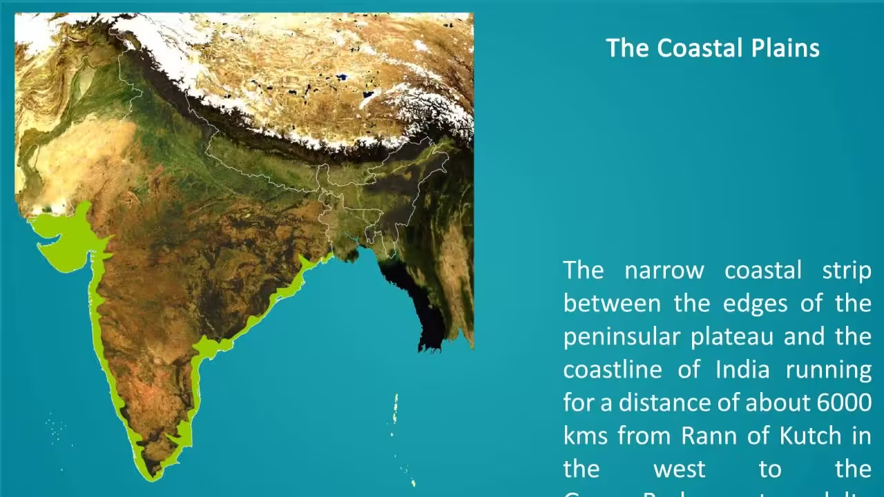
- The Indian Coastal Plains: The Indian coastal plains are divided into the eastern coastal plains and the western coastal plains. The western coastal plains are very narrow while the eastern coastal plains are broader and have many rivers flowing towards the east. These rivers form a fertile delta. The Sunderban delta formed by the rivers Ganga and Brahmaputra is the largest delta in the world.
- The Indian Islands: Lakshadweep and Andaman and Nicobar islands are two islands of India. While the Lakshadweep Islands are located in the Arabian Sea, the Andaman and Nicobar Islands are located in the Bay of Bengal. The latter group of islands was badly damaged by the tsunami (a giant sea wave generated due to earthquake on the ocean floor) which occurred in 2004.
Important Questions
- Multiple Choice Questions:
Question 1. The world’s highest peak is located in:
(a) Great Himalaya or Himadri
(b) Peninsular plateau
(c) Western Ghats
Question 2. Which of the following country does not share the land boundary with India?
(a) Afghanistan
(b) Myanmar
(c) Sri Lanka
Question 3. The capital of Manipur is:
(a) Aizawl
(b) Kolkata
(c) Imphal
Question 4. Lakshadweep islands are located in the:
(a) Arabian Sea
(b) Bay of Bengal
(c) Indian Ocean
Question 5. The Andaman and Nicobar islands lie to the south-east of the Indian mainland in the:
(a) Arabian Sea
(b) Bay of Bengal
(c) Indian Ocean
Question 6. In which part of India lays the Great Indian Desert?
(a) Southern
(b) Western
(c) Eastern
Question 7. Sri Lanka is separated from India by the:
(a) Isthmus
(b) Mountains
(c) Palk Strait
Question 8. In the east of India is the
(a) Arctic Ocean
(b) Pacific ocean
(c) Arabian sea
(d) Bay of Bengal
Question 9. Which of the following States is a member of the ‘ Seven Sisters ‘
(a) West Bengal
(b) Orissa
(c) Tripura
(d) Bihar
Question 10. Which is the standard meridian of India?
(a) 82 x 1 / 2° W
(b) 82 x 1 / 2° N
(c) 82 x 1 / 2° E
(d) 82 x 1 / 2° S
Question 11. Which of the following states does not common boundaries with Pakistan
(a) Punjab
(b) Gujarat
(c) Haryana
(d) Rajasthan
Question 12. The river which is called the Ganga of the south
(a) Krishna
(b) Tapi
(c) Narmada
(d) Godavari
Question 13. Peninsular plateau is
(a) Triangular in shape
(b) Circular shape
(c) Square in shape
(d) Rectangular in shape
Question 14. Which of the following is not the sea which surrounds the India Peninsula
(a) Pacific Ocean
(b) Indian Ocean
(c) Arabian sea
(d) Bay of Bengal
Question 15. The northern most limit of India is
(a) 73°2 N
(b) 37° 6′ N
(c) 45°4 N
(d) 67°3 N
- Fill in the blanks:
- The southernmost Himalayas are known as _______.
- Sahyadris is also known as _________.
- The Palk Strait lies between the countries __________.
- The Indian islands in the Arabian Sea are known as ___________.
- The largest state in India in terms of area is ________.
- Write true (T) or false (F):
- Aravali hill is one of the oldest ranges of the world.
- India has an area of about 1.28 million sq. km.
- The Greater Himalayas are also known as Himadri.
- The Tropic of Cancer (23°30’N) passes almost halfway through the country.
- India is located in the southern hemisphere.
- Very Short Questions:
- How many time zones are there in USA?
- How many time zones are there in Canada?
- In which hemisphere India is located?
- Which is the smallest state in terms of area?
- What is the other name of Middle Himalaya?
- Which two major rivers fall into the Arabian Sea?
- Which is the second most populous country of the world after China?
- In how many parallel ranges The Himalayan Mountains are divided?
- Where is the Great Indian Desert located?
- Where is Lakshadweep Island located?
- Short Questions:
- What is the north-south and east-west extent of India?
- What is the latitudinal and longitudinal extent of India?
- How Coral islands are formed?
- Write about the geographical boundaries of India.
- How many States and Union Territories are there in India? Which states have a common capital?
- Why do a large number of people live in the Northern plains?
- Long Questions:
- Write a note on political and administrative divisions of India.
- Write about coastal plains of India.
- Describe the major physical division of India.
- Describe the Peninsular Plateau with its major features.
- Mention the important features of the three main Himalayan ranges.
ANSWER KEY –
- Multiple Choice Answer:
- (a) Great Himalaya or Himadri
- (c) Sri Lanka
- (c) Imphal
- (a) Arabian Sea
- (b) Bay of Bengal
- (b) Western
- (c) Palk Strait
- (d) Bay of Bengal
- (c) Tripura
- (c) 82 x 1 / 2° E
- (c) Haryana
- (d) Godavari
- (a) Triangular in shape
- (a) Pacific Ocean
- (b) 37º 6′ N
- Fill in the blanks:
- Shiwalik
- Western Ghats
- India and Sri Lanka
- Lakshadweep Islands
- Rajasthan
- Write true (T) or false (F):
- True
- False
- True
- True
- False
- Very Short Answer:
- There are seven time zones in USA.
- There are six time zones in Canada.
- India is located in the northern hemisphere.
- Goa is the smallest state in terms of area.
- Himachal is the other name of Middle Himalaya.
- The rivers Narmada and Tapi fall into the Arabian Sea.
- India is the second most populous country of the world after China.
- The Himalayan Mountains are divided into three main parallel ranges.
- The Great Indian Desert lies in the western part of India.
- Lakshadweep Islands are located in the Arabian Sea.
- Short Answer:
- The north-south extent from Kashmir to Kanyakumari is about 3,200 km. And the east-west extent from Arunachal Pradesh to Kuchchh is about 2,900 km.
- From south to north, main land of India extends between 8°4’N and 37°6′ N latitudes. From west to east, India extends between 68°7′ E and 97°25′ E longitudes.
- Corals are skeletons of tiny marine animals called Polyps. When the living polyps die, their skeletons are left. Other polyps grow on top of the hard skeleton which grows higher and higher, thus forming the coral islands.
- India is a country of vast geographical expanse. In the north, it is bound by the lofty Himalayas. The Arabian Sea in the west, the Bay of Bengal in the east and the Indian Ocean in the south, wash the shores of the Indian peninsula.
- India is a vast country. For administrative purposes, the country is divided into 28 States and 7 Union Territories. Delhi is the national capital. Punjab and Haryana have a common capital i.e. Chandigarh.
- Northern plains are generally level and flat. These are formed by the alluvial deposits laid down by the rivers– the Indus, the Ganga, the Brahmaputra and their tributaries. These river plains provide fertile land for cultivation. That is the reason for high concentration of population in these plains.
- Long Answer:
-
- India is a vast country. For administrative purposes, the country is divided into 28 States and 7 Union Territories. Delhi is the national capital. The states have been formed mainly on the basis of languages. Rajasthan is the largest state and Goa is the smallest state in terms of area. The states are further divided into districts.
- To the West of the Western Ghats and the East of Eastern Ghats lie the Coastal plains. The western coastal plains are very narrow. The eastern Coastal plains are much broader. There are a number of east flowing rivers. The rivers Mahanadi, Godavari, Krishna and Kaveri drain into the Bay of Bengal. These rivers have formed fertile deltas at their mouth.
- The major physical divisions of India are:
- Himalayan Mountains: The Himalayan Mountains are divided into three main parallel ranges. The northernmost is the Great Himalaya or Himadri. The world’s highest peaks are located in this range. Middle Himalaya or Himachal lies to the south of Himadri. Many popular hill stations are situated here. The Shiwalik is the southernmost range.
- Northern Indian plains: The Northern Indian plains lie to the south of the Himalayas. They are generally level and flat. These river plains provide fertile land for cultivation.
- Peninsular plateau: To the south of northern plains lies the Peninsular plateau. It is triangular in shape. The relief is highly uneven. This is a region with numerous hill ranges and valleys.
- Coastal Plains: To the West of the Western Ghats and the East of Eastern Ghats lie the Coastal plains. The western coastal plains are very narrow. The eastern Coastal plains are much broader.
- Islands: Lakshadweep Islands are located in the Arabian Sea. These are coral islands located off the coast of Kerala. The Andaman and the Nicobar Islands lie to the southeast of the Indian mainland in the Bay of Bengal.
- The Peninsular plateau lies to the south of northern plains. It is triangular in shape:
- The relief is highly uneven.
- This is a region with numerous hill ranges and valleys. Aravali hills, one of the oldest ranges of the world, border it on the north-west side. The Vindhyas and the Satpuras are the important ranges.
- The rivers like the Narmada and the Tapi flow through these ranges. These are west flowing rivers that drain into the Arabian Sea.
- The Western Ghats border the plateau in the west and the Eastern Ghats provide the eastern boundary. While the Western Ghats are almost continuous, the Eastern Ghats are broken and uneven.
- The plateau is rich in minerals. It is black soil area which provides fertile land for cultivation..
- The important features of the three main Himalayan regions are:
- Greater Himalayas: These mountains are also called the Himadri. These are highest of all mountains. They run from Indus to Brahmaputra. The highest peak is Mt. Everest (8848m). Others are Kanchenjunga, Dhaulagiri, and Nanda Devi, etc.
- The Lesser Himalayas: These are also called Middle Himalayas or Himachal Himalayas. Most of the hill stations are situated on this range.
- Shiwalik Ranges: These are the outer Himalayas. The average height of these ranges is about 1,200 metres.
Also Visit: Readspot

You may also like

Chapter 8: India- Climate, Vegetation and Wildlife

Chapter 6: Rural Administration (CIVICS)
